

 Each
morning, we analyze the upper air and surface data, forecast models,
satellite imagery, and other types of weather data. With
all this information,
we will forecast the best severe weather target area for the day.
Each
morning, we analyze the upper air and surface data, forecast models,
satellite imagery, and other types of weather data. With
all this information,
we will forecast the best severe weather target area for the day.We will depart our hotel between 9:00am and 11:00am after discussing the forecast and target area with our tour guests. We will refine the target area as the day goes on with any new information we obtain from our mobile Internet system and continual radar updates as we drive to the target area.
Due to prime storm chasing time being in the late afternoon and early evening hours, we try to find a locally popular restaurant for lunch, which may become our main meal of the day. By 4 to 6 p.m. we want to be in the vicinity of the severe weather target area on chase days, so late afternoon rest stops tend to be fast food or snack opportunities.
Since we may be in very rural areas for the afternoon and evening storm chases, stopping for dinner might not be possible. Please note that we will not stop for dinner once the active chase begins to avoid missing potential severe weather. We arrive at our hotel near dark. We never chase after dark because it's just too dangerous. When there are no storms or on non-chase days, we should arrive at our hotel around 5 to 7 p.m.
During your trip, you'll be part of an important service that relays timely information back to the National Weather Service to help prevent loss of life, injury and property damage in local areas affected by severe storms.
Sights and Storms
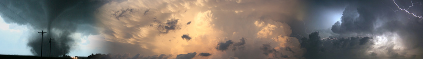
 Most
tours experience supercell thunderstorms and lightning shows at night,
but not every tour will see these phenomena. It's also important to
note that in some seasons only some tours will experience these things.
When conditions warrant, tornadoes form. We cannot guarantee
that you will see a tornado,
but we can say that you will have a great
experience seeing great storm structure and the beautiful scenery of the Plains.
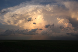
Most
tours experience supercell thunderstorms and lightning shows at night,
but not every tour will see these phenomena. It's also important to
note that in some seasons only some tours will experience these things.
When conditions warrant, tornadoes form. We cannot guarantee
that you will see a tornado,
but we can say that you will have a great
experience seeing great storm structure and the beautiful scenery of the Plains.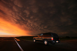 On
some tours, you'll be able to see university and government storm
chasers with Doppler on Wheels (DOW) equipment and other reasearch
tools.
From
time to time you may see various tornado intercept vehicles pass by on
your tour. These vehicles are equipped with camera equipment and are
able to withstand a direct hit from a weak tornado. It's a real
thrill to see a television show in production right there in Tornado
Alley, so be sure to look for camera crews while you're out there.
On
some tours, you'll be able to see university and government storm
chasers with Doppler on Wheels (DOW) equipment and other reasearch
tools.
From
time to time you may see various tornado intercept vehicles pass by on
your tour. These vehicles are equipped with camera equipment and are
able to withstand a direct hit from a weak tornado. It's a real
thrill to see a television show in production right there in Tornado
Alley, so be sure to look for camera crews while you're out there.Chase Territory
We will travel as far as necessary to areas that have the best chance for tornadoes with few trees for good viewing. This area covers Texas west of the Dallas-Ft. Worth area, Oklahoma west of Oklahoma City, Kansas in areas west of Wichita on northward where there are few trees, far eastern New Mexico, Kansas, Eastern Colorado, Nebraska, South Dakota, and Southeastern Wyoming. We do not chase where there are numerous trees because they severely limit the visibility of storms and tornadoes.